What you can see on the Little London cam
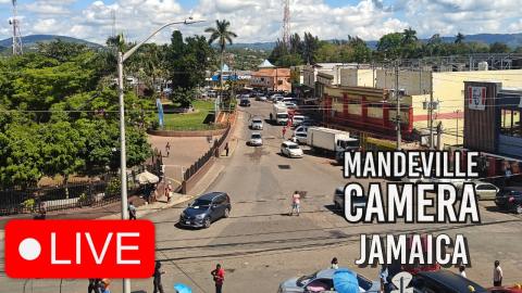
The camera looks over the main crossroads of town: a petrol station and its forecourt, a square with a small market, shop buildings painted in bright colours and the road leading off towards the trees. Route taxis and cars stop and go, and people cross the square through the day.
A country crossroads in Westmoreland
From above the main crossroads of Little London, this camera looks over a petrol station and its forecourt to a small square with market stalls, a row of shop buildings painted pink, yellow and blue, and the road leading off towards the trees and the hills of Westmoreland.
Route taxis stop and go and people cross the square through the day: it is a view of everyday life in a Jamaican country town, a long way from the resorts.
Westmoreland
Westmoreland is one of the flattest parishes in Jamaica, its plains planted for centuries with sugar cane, with the old sugar factory at Frome, near Savanna-la-Mar. The parish has some of the island's best-known beaches at its western tip, in Negril, and quiet fishing villages and country towns like Little London everywhere else.
When to watch Little London
Jamaica keeps the same time as Cancun all year, five hours behind UTC. The crossroads is busiest in the morning and late afternoon. The west of the island gets afternoon showers in the rainy months, from about May to October, and the hurricane season runs from June to November.
Nearby
The beaches and cliffs of Negril are about half an hour away to the west, and Savanna-la-Mar, the parish capital, with its seafront and its old fort, about 15 minutes to the east. The Roaring River and Blue Hole, a spring-fed river and swimming hole in the hills, is a short drive north of Savanna-la-Mar.
Getting there
Little London lies on the coast road between Savanna-la-Mar and Negril, about an hour and a half from Montego Bay airport. Cars drive on the left.