What you can see on the Cayman Brac cam
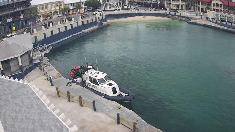
The camera, of the Port Authority of the Cayman Islands, looks from the shore over the pier at Creek, on the north coast, where cargo ships and supply boats tie up: the concrete pier, the dark ironshore rocks at the water's edge and the open Caribbean behind. A wide lens bends the horizon. It is a still image renewed every few minutes, useful to see the state of the sea on the north coast.
The pier at Creek, Cayman Brac
From the shore at Creek, on the north coast of Cayman Brac, this camera of the Port Authority looks along the cargo pier and over the dark ironshore rocks to the open Caribbean, through a wide lens that curves the horizon.
It is a still image renewed every few minutes, and the way to see the state of the sea on the north coast of the island.
The island of The Bluff
Cayman Brac is known for its diving, with walls, reefs and a Russian frigate sunk off the north-west coast in 1996 as an artificial reef, now named after the Caymanian swimmer Keith Tibbetts. On land, The Bluff draws climbers, hikers and birdwatchers, and its caves sheltered the islanders during the great hurricanes. It is quieter than Grand Cayman, with a few small resorts and a scattering of villages along the coast road.
When to watch Cayman Brac
The Cayman Islands keep Eastern Standard Time all year, five hours behind UTC, with no daylight saving. The north coast faces the trade winds and the winter cold fronts, when the sea can turn rough. The hurricane season runs from June to November.
Around Cayman Brac
Little Cayman, the smallest of the three islands, lies about 8 km (5 miles) to the west across a channel, with Bloody Bay Wall, one of the best-known dive sites in the Caribbean. Grand Cayman is some 145 km (90 miles) to the south-west.
Getting to Cayman Brac
Most visitors arrive on the flights from Grand Cayman, which land at the island's airport, at the western end, after about forty minutes.